History, causes and government interventions of tidal waves in Keta
The total land area of Ghana is 238,533 km2 with a coastline of 540km. The ocean coast is mainly high-energy type and has some lowlands, which are prone to flooding.
The coastal zone of Ghana is generally divided into three sections, the western, central and eastern-based on the geomorphology. The Eastern coast, which is about 149km, stretches from Aflao (Togo Border) in the East to the Laloi Lagoon west of Prampram.
The economic life consists basically of fishing in the lagoon or the sea and farming on the land.
Keta is a coastal town which is located at the west of Keta Lagoon inlet. The town is sited at the eastern end of a narrow coastal strip (Keta strip) that stretches from the east of the Volta estuary to the mouth of the Keta Lagoon. Keta lagoon, the largest lagoon in Ghana has large wetlands which extend to the Volta delta. The wetland is a designated Ramsar site under Ghana Wetlands Management Project. The coastal strip separating the lagoon freshwater from Gulf of Guinea seawater is believed to have been formed by sedimentary deposits from the Volta.
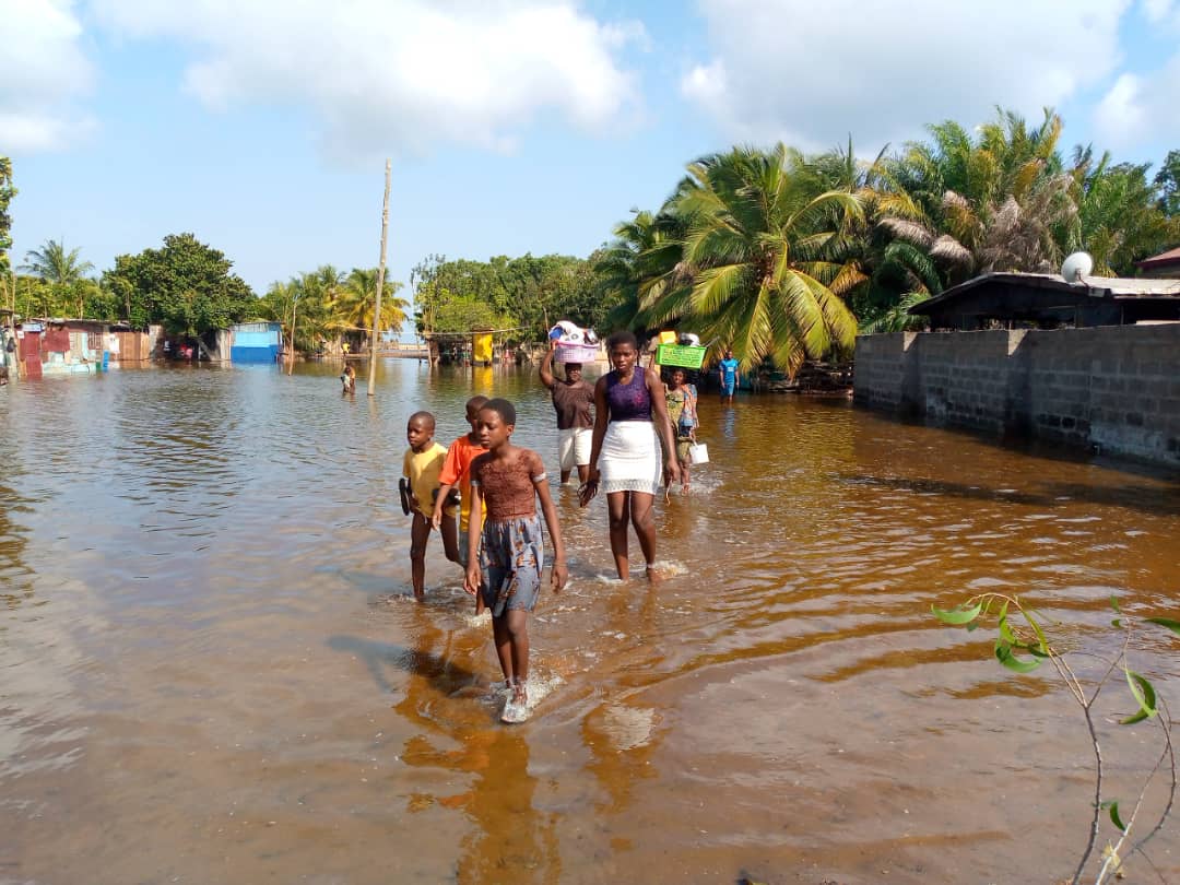
The increased erosion in Keta suggests that the reduction of coastal sediment supply caused by the Akosombo dam led to the fast erosion of the coastline down-drift the Volta estuary. This situation resulted in a quick recession and devastations on the shoreline and settlement between Keta and Hlove from 1965 to 2002. Residents along the Keta municipality coastal belts have for some years been enduring the devastating effects of tidal waves where the sea overflows its banks and submerges houses sited close to the shore.
In June 2015, Keta municipality was hit by tidal waves destroying 56 houses and leaving 627 people in the towns of Dzita and Fuveme homeless. Similarly, in June 2016, the communities of Fuveme, Kporkporgbor, Whuti, Srogboe, Dzita and Agbledomi were hit by tidal waves, displacing hundreds of people and damaging properties and farmlands. A cemetery at Fuvume was also affected by the waves. The perennial disaster recently hit the Keta municipality in November 2021 displacing about 3000 homes. Communities such as Abutiakope, Kedzikope and Keta Central were largely affected.
CAUSES OF THE TIDAL WAVES IN KETA
Sand Winning
Sand winning is the collection and transport of fragments of sand and raw materials for the construction of roads, bridges and built facilities for accommodation or other purposes. Although sand winning is banned along beaches in the country, it continues to be a source of sand supply for the real estate sector. It is an activity that is dominant in the coastal areas of Ghana and Keta Municipality is not an exception. With the decline in the two major economic activities (fishing and farming) in the municipality, the youth have resorted to sand winning as a source of income. The only barrier between the ocean and homes is carved away by the activities of sand winners. The activities created a channel for waves to attack and erode the beach systems due to the forcing wave energy. “If you can’t farm or catch fish, you can fetch sand and sell. It is in abundance,” Mawuli Aziati, a resident of Keta opined in an interview with the fourth estate. “It costs GHc 60 for a trip of sand. Even that is expensive for most people. So, they fetch it themselves. You don’t expect us to see free sand, and yet go searching for it elsewhere,” Mr. Aziati continued.
Rise In Sea Level and Climate Change
The entire coast of Keta is under serious threat due to its soft geology and low-lying topography. Climate change’s physical effects have caused the sea level to rise in recent years, resulting in higher tides that overflow their shores and end up in the communities along the Keta coast.
Part of Keta’s sandy earth is swept away and transported by the natural force of tidal waves during sea erosion. Tidal waves are already powerful, but they are aided even more by climate change, which causes extreme weather patterns. Several consequences could be expected from sea levels rise in Ghana. In particular, low-lying sandy coastal areas at the eastern coast such as the Volta Delta and Keta lagoon could be profoundly affected. The expected impacts of sea-level rise are: submergence of low-lying wetland and dryland areas; erosion of soft shores by increasing offshore loss of sediment; increasing salinity of estuaries and aquifers; raised water tables; and exacerbated coastal flooding and storm damage. These impacts will in turn influence coastal habitat, bio-diversity and socio-economic activities which is clearly what is happening today, especially in the Keta Municipality.
GOVERNMENT INTERVENTIONS
An attempt to find a lasting solution to this perennial disaster resulted in the establishment of the sea defense project during the administration of former President John Agyekum Kuffuor. The project was completed between 2001 and 2004. NADMO in 2007 identified Keta area as one of the 24 coastal erosion hotspots in Ghana where erosion has persisted for more than a century with no permanent solution.
In the same vein, 100 housing units of resettlement were completed in 2003. Three of the affected communities which were resettled are Vodza, Adzido and Kedzi. These projects were intended to intercept the reduced but significant current coastal sediment drift between Keta and Hlove, potentially halting the recession and providing shelter to those affected. The residents of the community at the time were adamant to relocate because they felt they would lose their livelihoods and resources.
In 2016, NADMO revealed that 573 housing units had been constructed accommodating a similar number of households between 2003 and 2015. These new communities were situated on part of the land reclaimed from the Keta Lagoon, about 1 mile from the coast. NADMO in the same year disclosed that the central government intends to continue the resettlement program when funds become available. This additional development can be attributed to both the John Agyekum and Attah Mills administration.
Recently, the phase one of a new sea defense project started in October 2019 with phase two yet to commence under President Nana Addo Dankwah Akuffo Addo’s administration.
The timely intervention of government from 1990 till date is commendable and deserves mention. That notwithstanding, pragmatic steps and policies have to be enrolled in providing a permanent solution.
CONCLUSION
The presence of a large Keta lagoon fronted by a settled barrier beach means that coastal settlements are at risk of flooding from landward (lagoon) as well as seaward. As a result, defending the cell frontage against rising sea levels is not only economically expensive but technically difficult.
According to a paper by Abdul-Moomin Ansong Salifu of Walden University, Relocation can be a successful adaptation response to slow-onset climate-induced environmental change in the eastern coast of Ghana. Relocation can, however, result in a lack of justice and fairness in the allocation of benefits and negative experiences of victims. His findings led to the proposal of a pragmatic governmental approach to developing a national relocation framework that ensures a successful resettlement process with key emphasis on the appropriate distribution of benefits and burdens of social life as well as mitigating negative experiences of victims.
Though relocation of three communities has been completed, the additional relocation of other communities identified by the central government must depend strongly on addressing the findings and recommendations for social justice in relocation, adaptation, and disaster recovery processes in order not to repeat the extremely negative experiences of the three Keta communities
SOURCES
Addo, K. A., Jayson-Quashigah, P. N., & Kufogbe, K. S. (2011). Quantitative analysis of shoreline change using medium resolution satellite imagery in Keta, Ghana. Marine Science, 1(1), 1-9.
Boateng, I. (2009, May). Development of integrated shoreline management planning: A case study of Keta, Ghana. In Proceedings of the Federation of International Surveyors Working Week 2009-Surveyors Key Role in Accelerated Development, TS 4E, Eilat, Israel, 3-8 May.
Boateng, I. (2012). An assessment of the physical impacts of sea-level rise and coastal adaptation: a case study of the eastern coast of Ghana. Climatic Change, 114(2), 273-293.
Salifu, A. M. A. (2016). Relocation Based on Slow-Onset Climate-Induced Environmental Change in Keta, Ghana (Doctoral dissertation, Walden University).
Comments are closed.